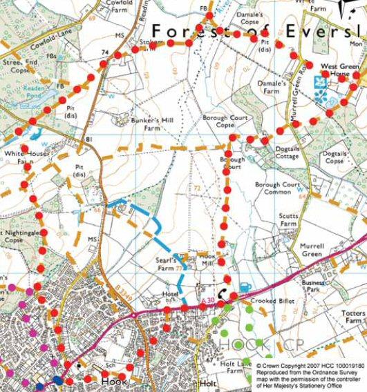
(5.4 miles / 8.6 km – 2 hours)
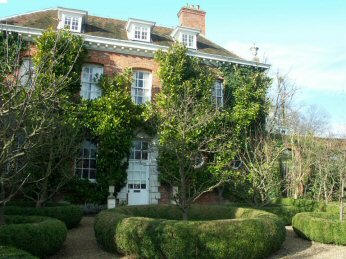
This walk takes you through bluebell woods and open fields to West Green House, with its garden full of follies and monuments and its tearoom and garden shop.
The walk follows the River Whitewater for some of the way, where it also passes a pub.
Download the GPS waypoints (in GPS Exchange format). To download the file to your computer, right-click on the link and select “Save target as” from the menu.
| Name / Position / Elevation | Bearing | Distance | Time | Comments |
| WP0001 SU 72439 54250 82 m | From the roundabout in Hook village centre, walk along London Road towards the garages. Just before them turn left down Reading Road. | |||
| WP0002 SU 72509 54340 80 m | 038°T | 114 m | 0:01 | After 500m, take the third road to the left down Goose Lane. |
| WP0003 SU 72424 54630 76 m | 344°T | 302 m | 0:04 | Follow the track around until it crosses a road (Great Sheldons Coppice). |
| WP0004 SU 72364 54765 73 m | 336°T | 148 m | 0:02 | |
| WP0005 SU 72274 54830 69 m | 306°T | 111 m | 0:01 | Cross road and walk about 10m to right and take footpath through the woods. (Note do not go straight across road over bridge.) |
| WP0006 SU 72364 55205 73 m | 014°T | 386 m | 0:05 | After about 350m, leave the wood through a gate and keep to path with the wood to your left. |
| WP0007 SU 72319 55470 75 m | 351°T | 269 m | 0:04 | At the corner of the wood (after about 250m), keep going straight heading towards a footpath sign at the top of small hill. |
| WP0008 SU 72254 55630 80 m | 338°T | 173 m | 0:02 | Go straight across at the sign and down the hill and walk past six big oak trees to your right. |
| WP0009 SU 72164 56005 69 m | 347°T | 386 m | 0:05 | Walk between the fishing lakes and cross the road at the car park exit. Walk 10m along the road to the right and enter the wood along the signed footpath. |
| WP0010 SU 72429 56185 69 m | 056°T | 320 m | 0:04 | After 150m, leave the wood and turn left keeping to the path beside the wood. |
| WP0011 SU 72639 56345 70 m | 053°T | 264 m | 0:03 | At the end of the field, cross into the next field and turn right following the field around by the side of the B3349 road. |
| WP0012 SU 72715 56345 70 m | 090°T | 75 m | 0:01 | Walk under pylon wires. |
| WP0013 SU 72800 56555 72 m | 022°T | 227 m | 0:03 | Cross the road at the sharp bend at the end of the field. Walk along the road for 20m and take footpath to the right into a thicket. (Take care here, this road can be busy and cars fast). After passing a big rabbit warren, cross a small stream and head out across a large field on the path. |
| WP0014 SU 73165 56645 65 m | 076°T | 376 m | 0:05 | |
| WP0015 SU 73365 56655 60 m | 087°T | 200 m | 0:02 | |
| WP0016 SU 73460 56725 58 m | 054°T | 118 m | 0:01 | At the other side (650m), follow the path by the River Whitewater bearing a little left. |
| WP0017 SU 73515 56860 58 m | 022°T | 146 m | 0:01 | Cross stile and then the river at the bridge on the right. Cross stile after bridge and head for gate at far right corner of the field. |
| WP0018 SU 73640 56725 58 m | 138°T | 184 m | 0:02 | Cross stile there and head slightly to the left up to the corner of the next field. You will pass two WW2 pillboxes (on both sides) as you walk through this field. |
| WP0019 SU 73890 56700 69 m | 096°T | 251 m | 0:04 | |
| WP0020 SU 73910 56725 69 m | 039°T | 32 m | 0:00 | Follow path to the left around a green hut. (Beware: clay pigeon shooting takes place near here sometimes.). Continue and take the stony track for 300m until meets to the road. |
| WP0021 SU 74175 56485 74 m | 132°T | 358 m | 0:05 | Cross and walk around 10m to right and take footpath through iron gates on your left. Walk on path with avenue of oak trees on your right. After about 400m from road, you pass the grounds of West Green House on your right. |
| WP0022 SU 74460 56400 71 m | 107°T | 298 m | 0:04 | |
| WP0023 SU 74605 56415 70 m | 084°T | 146 m | 0:01 | The path then meets the road. Turn right and after 10m, walk down the gravel entrance into West Green House. |
| WP0024 SU 74560 56305 70 m | 203°T | 119 m | 0:01 | The house is NT property and is open Easter to end of September, Wednesday to Sunday between 11.30am and 4.30pm. There are gardens, shop, tea room and small garden centre to visit. On leaving the house, continue on path through an iron gate (with the garden centre on your right and a greenhouse to your left). |
| WP0025 SU 74510 56225 70 m | 212°T | 94.4 m | 0:01 | Continue on the path for about 500m along the edge of a wood (to your left) until you come to a road. |
| WP0026 SU 74265 56085 70 m | 241°T | 282 m | 0:03 | |
| WP0027 SU 74085 56060 70 m | 262°T | 182 m | 0:02 | Cross, go through the gate and take the track. Horses can often be seen in the paddocks here. |
| WP0028 SU 73950 55950 68 m | 231°T | 174 m | 0:02 | Cross the gate at the end of the track and walk past the old green caravan down the path on the right and past Borough Court House (beware dog!). |
| WP0029 SU 73895 55990 68 m | 306°T | 68 m | 0:00 | |
| WP0030 SU 73825 55965 65 m | 251°T | 74.4 m | 0:01 | At the house entrance, turn right through two gates into the field. After 25m, cross another gate in the middle of the field. |
| WP0031 SU 73685 55985 60 m | 278°T | 141 m | 0:01 | Bear right towards bridge and cross over it. Then turn left along the Whitewater River path. |
| WP0032 SU 73675 55890 60 m | 186°T | 95.6 m | 0:01 | |
| WP0033 SU 73650 55700 61 m | 188°T | 192 m | 0:02 | You cross a stile after 200m. Then after a sharp bend in the river to the left, keep to the path which leaves the riverside and goes across the field with a hedge to the right |
| WP0034 SU 73610 55155 64 m | 185°T | 547 m | 0:07 | After about 500m, cross style at the end of the field and go down path between two hedges that is like a tunnel. Continue by a small stream (ignoring footpath to right), pass entrance to Hook Mill on your left and out on to a tarmac road. Follow this until you get to the Crooked Billet pub (on left). |
| WP0035 SU 73675 54805 65 m | 170°T | 356 m | 0:05 | Turn right along A30 pavement towards Hook. Pass Shack Café on your left. Cross the road just after the Hook House Hotel. |
| WP0036 SU 73225 54715 73 m | 259°T | 459 m | 0:06 | Take the footpath to the left by the post box signed Holly Ridge. |
| WP0037 SU 73220 54600 73 m | 183°T | 115 m | 0:01 | Cross road (Holt Way) and continue on tarmac path. At the end of the tarmac, bear slightly left on a path by the edge of a wood. |
| WP0038 SU 73165 54465 72 m | 202°T | 146 m | 0:01 | At the end of the wood, turn left and use underpass to cross road. |
| WP0039 SU 73090 54335 71 m | 210°T | 150 m | 0:02 | Turn left into Wheelers Hill. After #3 Wheelers Hill, turn right up the path. |
| WP0040 SU 73009 54225 71 m | 216°T | 136 m | 0:01 | Continue along this passing Hook Junior School on your right. |
| WP0041 SU 72814 54275 78 m | 285°T | 201 m | 0:03 | Cross Church View into Band Hall Place and take the path to the left of #8 until you arrive back at Hook centre. |
| WP0042 SU 72464 54195 82 m | 257°T | 359 m | 0:05 | Hook centre has local shops and three pubs all within two minutes walk: The Raven Hotel, The Old White Hart and the White Hart. |
| Totals: | 8.78 km | 2:05 |


